Share on facebook
Share on twitter
Share on telegram
Share on email

Map of Los Alamos – Manhattan Project and Trinity Test Site

  • Trinity Site
  • 33.603, -106.589
  • 33.6555 -106.591
  • 33.638, -106.608
  • 33.656, -106.571
  • 33.852, -106.661
  • 33.841, -106.63
  • 33.758, -106.595
  • McDonald Ranch House
  • Oscura Peak
  • Mockingbird Mountains
  • North Oscura Peak
  • Stallion Army Airfield
  • Little Burro Mountains
  • Jornada del Muerto Volcano
  • White Sands Missile Range
  • Los Alamos National Laboratory
  • Bradbury Science Museum
  • Bandelier National Monument
  • Los Alamos Historical Museum
  • Fuller Lodge
  • Pajarito Ski Mountain
  • Valles Caldera National Preserve
  • Ashley Pond Park
  • White Rock Overlook Park

Trinity Site

The Trinity Site is situated in the White Sands Missile Range in southern New Mexico. It is historically significant as the site of the world’s first atomic bomb detonation. This event marked a pivotal moment in the Manhattan Project, the secret U.S. project during World War II aimed at developing nuclear weapons.

The Trinity Site is now a National Historic Landmark. It is open to the public only twice a year, typically the first Saturdays of April and October. Visitors can see Ground Zero, where the bomb was detonated; the remains of the base of the test tower; and a monument marking the location of the explosion. Trinitite, the green glass created by the bomb’s heat, can still be found in the area, although removing it is prohibited.

While there is still some residual radiation at the site, authorities maintain that it is safe to visit during the designated open houses. The levels of radiation are low, similar to what one would be exposed to on a round-trip cross-country flight.


Trinity Test Site Map

Table of Contents

Location of Los Alamos

Los Alamos is a town in Los Alamos County, New Mexico, United States, and is known for its significant history in the development of the atomic bomb during World War II as part of the Manhattan Project. The town is located on the Pajarito Plateau, which is on the eastern edge of the Jemez Mountains in Northern New Mexico.

Los Alamos Map

Geography

Geographically, Los Alamos is situated at an elevation of approximately 7,320 feet (2,230 meters) above sea level. The area experiences a mountainous climate, with snowy winters and mild to warm summers, reflecting its high altitude and desert location.

Los Alamos Region

The region surrounding Los Alamos is rich in natural beauty and includes several national parks and forests, such as the Bandelier National Monument and the Santa Fe National Forest. These areas offer a range of outdoor activities including hiking, camping, and wildlife viewing, thanks to their diverse ecosystems and scenic landscapes.

Manhattan Project

The town itself is divided into several neighborhoods, including the historic district, where many Manhattan Project properties are located, and newer residential areas. Los Alamos is known for its scientific and research contributions, largely due to the presence of Los Alamos National Laboratory, one of the largest science and technology institutions in the world, which continues to be a major employer and influence in the town.


Los Alamos County

Los Alamos County, which includes the town of Los Alamos and the nearby community of White Rock, is relatively small in terms of population but is noted for its high level of education and quality of life, reflecting its history and ongoing role in scientific research and development.

Points of interest

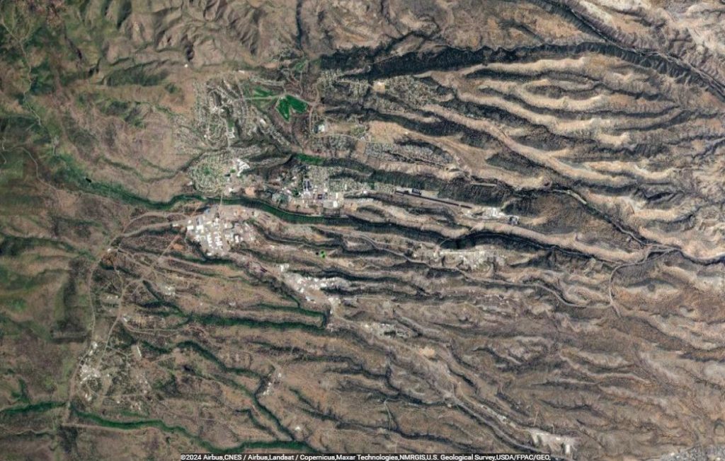
Los Alamos, New Mexico, is known for its rich history and beautiful natural surroundings. 

Los Alamos National Laboratory (LANL)
While not open to the general public, the Laboratory is a significant part of the town’s history and identity. It was the secret site for the Manhattan Project during World War II, where scientists worked on developing the atomic bomb.

Bradbury Science Museum
This museum offers interactive exhibits on the history of the Manhattan Project, nuclear weapons, and the current scientific research conducted at LANL. It’s a great place to learn about the town’s unique history and contributions to science.

Bandelier National Monument
Located just outside Los Alamos, this national monument offers stunning canyons, mesas, and ancient Pueblo ruins. Visitors can enjoy hiking trails, wildlife viewing, and learning about the ancestral Puebloan people who once inhabited the area.

Los Alamos Historical Museum
Situated in the town’s original guest cottage, this museum showcases the history of the region, from the ancestral Puebloan era to the present, including the development of the atomic bomb.

Fuller Lodge
Originally built as a boys’ school, this historic building served as a gathering place for Manhattan Project scientists and their families. Today, it’s used for community events and is a symbol of the town’s history.

Pajarito Ski Mountain
Just a short drive from Los Alamos, this ski area offers winter sports activities like skiing and snowboarding, with trails for various skill levels.

Valles Caldera National Preserve
This massive volcanic caldera is a scenic natural wonder near Los Alamos. It offers a range of outdoor activities, including hiking, fishing, and wildlife watching.

Tsankawi Section of Bandelier National Monument
A separate part of Bandelier, Tsankawi offers unique experiences with its cave dwellings, petroglyphs, and unexcavated ruins, all accessible via hiking trails.

Ashley Pond Park
Located in the heart of Los Alamos, this peaceful park is named after Ashley Pond, who founded the Los Alamos Ranch School. It’s a great place for relaxation and community events.

White Rock Overlook Park
Offering panoramic views of the Rio Grande Valley and the Jemez Mountains, this is a perfect spot for photography, picnics, and sunset viewing.