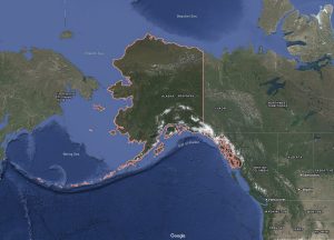
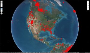
When you open the live fire map, you will see dots or colored spots on the map. Each dot shows where a fire was detected. The colors often indicate how recent the fire is, how confident the system is that it’s a fire (low, medium, or high confidence), and how strong or intense the fire is. By clicking on a dot, you can see more information like the exact location, detection time, and which satellite captured the data.
Live fire maps are extremely important for many reasons. Firefighters and emergency teams can use them to quickly see where new fires have started and respond faster. Scientists and environmental groups rely on the data to monitor deforestation, volcanic activity, and other events involving heat. For the public, fire maps are a useful way to stay informed about fire risks in their own country or anywhere around the world.
Most live fire maps offer additional features that make them even more helpful. You can look at fires detected in the past 48 hours.